Friday, December 18, 2009
Saturday, December 12, 2009
Flagstaff Blizzard of '09

Bob's house across the way, 9am, Tuesday
Winter hit us hard last Monday (December 7) when some 24+ inches fell in as many hours. By evening, winds reached speeds of 50-60 mph, making the first storm of '09-'10 a blizzard by definition. What's more, it was the first blizzard to hit Flagstaff in a decade. The town was pretty much shut down from Monday night until mid-Tuesday (all schools and universities closed). Stranded elk hunters were still being rescued as of Friday. Some will probably have to wait until spring to get their cars/trucks/campers, and I suspect anything they shot but had to leave behind will have been picked cleaned by the coyotes and mountain lions long before then.
Thursday, December 10, 2009
Summer '09, Third Installment: Bear Wallow and Baldy
Though tiny in size, Bear Wallow's rugged thick woods and killer views off the Mogollon Rim make up for what it lacks in vastness: http://www.sangres.com/arizona/national-forests/apache/trails/bearwallow.htm . Lara, Bo and I hit the trail Saturday morning and soon met up with our buddy Jerry and his party. With a centrally located base camp we used Sunday to explore up Schell Canyon to the Mogollon Rim. Myself and Jerry's brother's friend (whose name I can't remember at this point) continued on to Rose Spring, which turned out to be dry, before heading back to camp. The next morning we all hiked out and rewarded ourselves with a hearty breakfast at the awesome Bear Wallow Cafe in Alpine.

Trekking through the woods

Jerry's then-new puppy, Choppo.

Bo the Dog, looking inpatient

Mogollon Rim from the junction of RoseSpring and Schell Canyon Trails

We hit this 15+ mile loop sometime in mid-July. Super cool area that is very accessible yet didn't have as many overnight hikers as you'd expect. The lower portions of West Fork Trail where we started the hike is dominated by meadows edged with pines and bisected by the meandering West Fork of the Little Colorado River, a major Arizona water way that has its headwaters here. More information on this killer backpack through gorgeous country can be found here: http://www.sangres.com/arizona/wilderness/mtbaldy.htm .
P.S. My camera battery ran out almost immediately so we only got a few shots.
Sunday, November 29, 2009
Summer '09, Second Installment

The hike itself is not all that burly, more gently rolling hills cut with draws, but doing 12 miles when you start at 1pm was a bit of kick in the teeth. I was lucky to run into some nice ladies along the Rim who gave Bo and I there extra water (we were out). We camped at General Spring Cabin that night and then looped back to the car by 2pm the next day, making it about 18 miles total. Note to all heading out there: I only did the western half of the trail because of time constraints and the fact that a burn was occuring in the eastern half of the loop. You could easily spend 2 nights doing the whole system. For more info see this link http://www.fs.fed.us/r3/coconino/recreation/mog_rim/cabin-loop-trail.shtml .

The route started at Pinchot Cabin then took Houston Bros Tr to Barbershop to General Crook to Fred Haught back to Pinchot.

Remains of a cabin fireplace at Aspen Spring on the Houston Bros Tr

Same as above, different angle

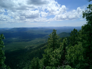
Million dollar views off the Mogollon Rim via the General Crook Tr
That's all I got in me for now. More trip shots to come from places like Bear Wallow and Mt. Baldy Wilderness Areas, not to mention a solo trip down James Canyon that entailed 2 rappels and many swims through pools that were frigid even in August.
Wednesday, November 04, 2009
Summer '09, First Installment
All in all, this past summer was a solid one. Though I didn't rock climb as much as I would have liked, I did more than enough backpacking. Also got in some canyoneering and even a road trip. The following is a bullet pointed summary of "My Summer Vacation" ( think back to grade school after a summer off.....nostalgia, eh?).
1. Hiking up Humphrey's Peak (sometime in May)
I can't remember exactly when I did this but it was my 3rd attempt to the summit of Arizona (12,634 ft) with my 2nd successful peak bid. The hike isn't particularly difficult but a blizzard at
the saddle like the one I experienced during my first attempt will stymie even the most intrepid of hiker. Bo the Dog came along this time and had a good time hanging out on the roof of the region. For more info on Humphrey's check out this link:

2. Overnight trip into the lower end of West Clear Creek Wilderness Area (5/22-23). Though I forgot the camera, I did remember to bring Bo. We hiked in about 6 miles and made camp at one of the many creek crossings. Yes, there are about a million redneck idiots who visit the lower end of this unique desert riparian zone, but one can only carry two 30 packs so
far. Thus, tranquility that befits its Wilderness designation awaits any who dare venture more than 2 miles deep. Info on W. Clear Creek can be found here: http://www.fs.fed.us/r3/coconino/recreation/red_rock/west-clear-creek-boat.shtml

3. Full Moon Ride (6/6)
This was my 3rd time doing this ride which starts at Cinder Hill Overlook in Sunset Crater National Monument and ends some 20 miles later at Wukoki Ruins in Wupatki National Monument. Luckily, it's down hill almost the entire way, and as the name suggests, we ride solely by full moon. Though the ride isn't much of a physical challenge, its nocturnal nature coupled with the silhouetted volcanic craters that blanket the area make the Full Moon Ride a classic of Flagstaff living. A of both parks including start and end points of the ride can be seen here: http://www.nps.gov/PWR/customcf/apps/maps/showmap.cfm?alphacode=wupa&parkname=Wupatki%20National%20Monument
Monday, July 20, 2009
Retro Blogging # 4: Aravaipa Canyon

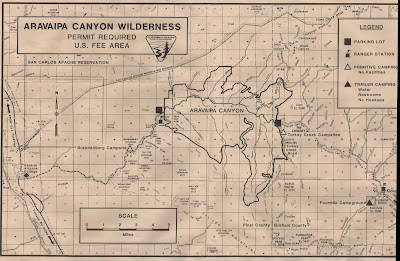
Aravaipa Canyon....what to say other than even this Atheist would call it heavenly. Jerry and I spent 2 nights camped across from Booger Canyon (as in that which comes from the nose). We explored a section of that branch as well as Hell's Hole Canyon, aka Deer Creek. I'm gonna stop now and let the pictures, this map, and the following link do most of the talking: http://www.blm.gov/az/st/en/arolrsmain/aravaipa.html .

Click on this and all other images to enlarge

Start of the Canyon proper

The "trail" is the creek

The "Hole" from which Hell's Hole Canyon may get its name

Or is this the "hole? Spring grotto deep in Hell's Hole

Like something out of terrarium

Ubiquitous vegetation, home to some 10+species of fish, some of which are threatened/endangered

A view from the camp

Hole in Booger Canyon

Wide but beautiful load
Sunday, May 10, 2009
Retro Blogging # 3: Hell's Gate Hike

Hell's Gate is the name of the confluence of Tonto and Hager (sp?) Creeks, just east of Payson, AZ. You can get to the Gate by backpacking/swimming up the Tonto (so I've been told) but most people opt for the 7 mile overland route. Though this is a recommended 2 day backpack or longer, Lara, Bo, and I did it all in one burly 14 mile day. The last 1.5 mile drops something like 1300 feet, making for one hell of a hike back out.....but the views along Apache Rideg of distant Mazatzals and the 100 foot walls of Hell's Gate make it well worth it. True, Bo did take off for about 30 minutes during our hike out, all at a time when we had little day light left and still 5 miles to hike, but overall, I really dig this area and recommend it to anyone looking for a challenging day hike with a rewarding turn around point.

The first several miles had lots of water from the melting snow.
Saturday, May 09, 2009
Retro Blogging # 2: Superstition Mountains Backpacking Trip
 Unkown spring at the junction of Coffee Flat and Red Bluffs Trails?
 Despite the rager that was NYE, myself, Lara, Bo the Dog and our buddy Jerry hit the road around 10am on January 1. Our destination was the Peralta Trail Head of the Superstition Wilderness. Wilderness is used loosely here as this area is very near ever expanding Phoenix (and everything that sucks about it) and hence draws lots of hikers. However, our route - Lost Dutchman's to Coffee Flat to Red Bluff's Divide (camp site) through La Barge Canyon and over Miner's Needle via another section of Dutchman's - saw few fellow hikers. This was especially true once we got into the Red Bluffs. This area is very beautiful and relatively remote......it's also full of Cat Claw, a bush which tears at you as much as its name suggests. After 7 miles of getting torn up by this beastly plant, we made camp at the top of La Barge Box Canyon. The next day's descent through La Barge had awesome views of distant peaks and nearer saugaro fields. Water in the box canyon was plentiful due to a couple of massive December storms. From the bottom of La Barge we turned left and climbed to the base of Miner's Needle before descending back to the trail head and our car.

Bo the Intrepid, with pack
 Campsite at the top of La Barge
Looking down La Barge Box
Retro Blogging # 1: NYE 2008
It's time to play blog catch up:
We spent 12/31/09 in fair Flagstaff. First a bluegrass show at the Orpheum and then to the streets for the Great Pine Cone Drop, Flag's answer to NYC's Timesquare party. Afterward, we headed to Pay 'N Take, a liquor store that allows you to drink inside. They also sell toiletries. Not a bad night overall.

We spent 12/31/09 in fair Flagstaff. First a bluegrass show at the Orpheum and then to the streets for the Great Pine Cone Drop, Flag's answer to NYC's Timesquare party. Afterward, we headed to Pay 'N Take, a liquor store that allows you to drink inside. They also sell toiletries. Not a bad night overall.

Drunk guy in foreground, pine cone in background.
Sunday, February 08, 2009
Another Sedona Hike
On Saturday my friend Patrick and I, along with Bo and Toby, hiked up Secret Canyon Trail to David Miller to Bear Sign then back to our car via a jeep road. 6.5 miles total through some seldom visited Red Rock country. We were surprised to find a lot of water still in the normally dry creek beds. Bo and Toby had a good time with that.


Subscribe to:
Comments (Atom)


 Last proper view of Hell's Gate before heading out


