
Wednesday, December 24, 2008
Wednesday, November 26, 2008
And then there were 4.....


New dog! That brings the zoo's population to 3 cats and a mutt. His name is Bo and I like him better than all the Pilgrims combined.
Sunday, November 16, 2008
New Cat

Well, not that new. We got her back in late-September but I've been too damn busy to post anything until now. Her name is Nola. She's half-domestic short hair, half Abyssnian, and 100% dirty Rez cat. We love her anyway.
Tuesday, October 21, 2008


Tuesday, August 05, 2008
June Road Trip to Chicago
This summer has been a long and adventurous vacation....the "calm" before the storm if that makes any sense.....it should make some sense given that in the next few weeks I'll be moving into a new place with my girlfriend and our two cats, looking for work, and finally, starting nursing classes at Coconino Community College on August 25. That last one is a big change for me, a major right turn from my previous path of working in education. I'm looking for something new, something that's both challenging and supportive of my lifestyle (aka, 3 or 4 day work weeks, job opportunities just about everywhere). I'll have to see how it all goes, but am pretty excited about the change of pace.
But back to the summer: my girlfriend had an internship in Chicago from mid-June 'til the end of July. I had a trip to Honduras and Guatemala planned from 6/23-7/24 (photos and a report to follow one of these years). So, we decided to combine our paths by taking a long road trip to Chicago where she'd do her internship and I'd hang out with family/friends before flying to Honduras. Our path was as follows:
- Flag to Santa Fe: we stayed with Lara's family, did some hiking and rock climbing around town, got ready for our roadtrip, and just relaxed.
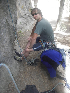
Me roping up at Las Conches, a cool little crag near Jemez Springs, NM.
- Santa Fe to Fort Collins, CO: We stayed with and old friend here for a night and checked out several local breweries. FC is an awesome town that I wouldn't mind making home one of these days. However, we have no photos of this or anything else between Santa Fe and northern Michigan. This is my fault as I accidentally deleted all the files on Lara's camera. It felt like we had been robbed.....anyway, I'll just narrate the rest 'til we get to Michigan.
- Fort Collins to Wall, SD: Wall is the classic tourist trap town, so much so that it's charming. This is the home of the infamous Wall Drug store where patrons can take photos with statues of Buffalo Bill Cody, Wyatt Earp, and a giant jackolope. Nearby lies the Badlands National Park.
- Wall, SD to Canby, MN: this is my mother's home town and the site of my grandparents' graves. It also has an amazing pizza joint that also serves up deep fried dill pickles (they're amazing). We stayed with some old family friends there and left early the next morning.
- Canby, MN to rural northeastern Wisconsin: Our plan here was to camp at Kosher's rafting then raft the Peshtigo the next morning. We did the former but ditched the latter: the weather was cold and overcast when we awoke. Not exactly rafting weather unless you're really committed.
- Rural northeastern Wisconsin to Glen Arbor, MI: We had planned to stop in Munising, MI, a small town near Pictured Rock National Lakeshore in the Upper Peninsula for some hiking and camping. Once again, weather didn't really cooperate. June brought lots of rain to the midwest, and while Michigan didn't get nearly as much as places like northern Iowa and southern Minnesota, it still wasn't ideal camping weather. So, we pushed through the U.P. then across the Straits of Mackinaw to Glen Arbor. Glen Arbor is a small hamlet nestled in between parts of the Sleeping Bear National Lake Shore.
 Sleeping Bear Harbor
 Kayaking the Crystal River, an annual event for many years now
 Hanging out in the Ghost Forest on Sleeping Bear Point
 Hiking from Pierce Stocking Drive to the top of the Dune Climb
 Flying down the Dune Climb
 A shot of North Manitou Island
 On the pier of Sleeping Bear Harbor
 Little and Big Glen Lakes. Formed by Glaciers, these lakes were originally a harbor of Lake Michigan. The outlet of the ancient harbor is where Glen Arbor currently sits.
- Glen Arbor, MI to Chicago. I spent about a week in the suburbs of Chicago before heading down to Honduras on 6/23. Lara had a place in the South Loop for an internship she was doing. The following shots are all within walking distance of where she lived.
 Buckingham Fountain as seen from Congress Parkway.
 A sliver of the Chicago skyline with Buckingham Fountain in the foreground
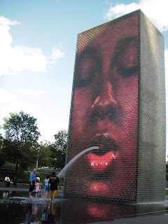 The post-modern fountain in Millenium Park. There's an identical fountain about 75 feet across from this one, both of which have projections of various faces throughout the day. It's a great place to hangout and read for getting a little wet during those muggy Chicago days.
So that's the road trip in a nutshell. Next up is the Central America portion of the summer. Stay tuned.
Wednesday, July 09, 2008
Failed Attempt to Summit Humphrey's Peak
It's been a busy summer....some trip reports are long past due. First up is a failed assault against Humphrey's Peak. At 12,634 ft, Humphrey's is the highest point in Arizona. It gets a lot of snow (yes, there is snow in Arizona), even in spring and summer. Case in point: our ill-timed hike back in May. Patrick, Elyse and myself knew we'd have some snow, but didn't think it'd be so thick that the usually easy-to-follow trail was non-existent. It of course didn't help when a storm moved in before we had even reached the tree line. With what looked to be near white out conditions well below the summit, we elected to turn back, comforted by the fact that this ancient peak is not going anywhere anytime soon.

Where things started to get ugly....

The "trail"
Monday, March 24, 2008
2008 Backpacking Trip #2: Sycamore Canyon Wilderness Area
I’ve got the backpacking bug it seems. After three nights in a warm bed and modern house, my roommate and I decided it was time to do a leisurely backpacking trip into the south end of Sycamore Canyon. We chose the Parson’s Spring trail which is accessed via a dirt road outside Cottonwood. Having not paid much attention to the map, I neglected to prepare for the five creek crossings we would face. Compounding this was the high volume of water Sycamore has right now due to a pretty wet winter. I tried crossing with my boots off and ended up hurting my bare feet. So, I did like any sane person would: just walk right through the creek crossings as if I wasn’t actually knee to waist deep in chilly water. After 3.5 miles of this we reached a small camping area near Parson’s and hung out for the night. Hiked out the next day around 11am. Like I said, it was a leisurely trip, really just an excuse to get out of the house and see a cool area.
 Rim view of Sycamore creek as it flows out of Sycamore Canyon
 The ubiquitous Cottonwoods and Sycamores of the Canyon's reparian zone
Red rock walls of the canyon
 A calm but wide part of Sycamore Creek
 Wet boots!

On the ride home we stopped for Mexican food in Cottonwood...right across from "Ye Ole Hippie Emporium". While we ate lunch, two guys came in to eat, one carrying a pistol on his hip. Very Wild West. Very Arizona.
Sunday, March 23, 2008
29 Mile Canyon

On March 7, a few of us attempted to reach the Colorado River via 29 Mile Canyon. I say attempted because we didn't actually making it. Faced with a possible hike out after dark, during which we would have had to navigate a 1000 foot vertical gain in about a mile, the group decided to bail after getting a mere glimpse of the seemingly elusive Colorado.
29 Mile is a "side canyon" to the Grand Canyon and is fed by the Shinumo Wash. Located on the Navajo Reservation via dirt roads, this hidden gem sees few visitors. However, what awaits the intrepid hiker is more than worth the effort.....even if their ultimate destination is never realized.
29 Mile Canyon can be seen above and to the left of Shinumo Altar

Starting the hike

Shale-like sandstone on the dry creek bottom

The Colorado can be seen just barely through the gorge walls.

Shadows grow as the day progresses
Thursday, March 20, 2008
2008 Backpacking Trip #1: The Mazatzal Wilderness Area

Unemployment has its benefits, such as the ability to go backpacking at any given time. I did just this with my girlfriend and two friends last weekend. On Friday, March 14, we drove to the Sheep Bridge Trailhead in Tonto National Forest. The road there was 38 miles of rough and tumble driving, complete with several creek crossings that my Honda CRV handled just fine. We spent Friday night camped on the beach below the Sheep Bridge (named that because they used to run sheep through the Mazatzal Mountains via this bridge over the Verde River). Our company was a bunch of ATV riding rednecks. They decided it would be hospitable to fire off assault rifles at 11pm. Then they tore the beach and trails up in the morning with their motorized toys. Call me an outdoor elitist if you will, but I don’t agree with this type of recreation. This people have no respect for the beauty of the natural environment, nor do they have any healthy fear for what the desert can do to a man who doesn’t come equipped with a 4x4 full of food, beer, guns, and a battery operated TV. In short, they detract from wild places in the worst ways possible.
Thankfully, the trails on the east side of the Verde were too narrow for their stupidity to flourish. On Saturday morning we had a big breakfast and set off towards the Mazatzal Wilderness Area, leaving our patriotic countrymen (after all, if you don’t like beer at 10am, ATVs, and guns, you must not be an American, right?) behind in a matter of minutes. We hiked through Sonoran Desert on the Willow Springs Trail, following a creek dotted with Cottonwoods for the first few miles before heading into the high country. Parts of the trail were hard to find and definitely difficult due to lose rocks and steep climbs. Arizona has seen a lot of rain this winter so the desert was pretty green and the creeks were unusually full. After 7 or 8 miles, we arrived at Willow Spring around 5pm and camped at this oasis for the night. Water was plentiful there.
By 9am on Sunday, the weather had taken a turn for the worst. Clouds gathered and temperatures dropped. Still, we wanted to put a couple of miles in so we made for Mountain Spring, just a few miles away. The trail ahead of us climbed steeply onto a ridgeline. We could see rain in the distance but no thunder/lighting so we weren’t worried. After about 45 minutes, it started to not rain but SNOW as we traversed the ridge. Luckily, it wasn’t blinding. It let up after about 20 minutes as we continued our trek. We reached Mountain Spring in the early afternoon and found an old corral and base camp from the sheep herding days. It was a little eerie but made a good campsite. We had lunch and then napped in the tents a bit. Temperatures hovered at 40 degrees maximum. That night we had a big dinner and even bigger fire as we struggled to fight the cold. It snowed some more that night.
Monday morning saw more cold temps and a little snow on the ground from the previous night. Spirits were pretty low….we debated whether we should stay another day at Mountain Spring and wait for the temperature to rise, or if we should just head on to the Dutchman Springs area via the Dutchman Trail (#22?). We decided on the latter. This was the smart thing to do since the temps soon warmed up throughout the region. At the same time, we began to descend into the Sonoran Desert. Soon we found ourselves hiking in T-shirts, surrounded by purple lupine, Mexican poppy, and other desert wildflowers that had blossomed overnight from the storm’s precipitation. The going became pretty slow on this section because of cacti that were spilling into the trail, but the desert’s beauty more than compensated.
As we approached Dutchman Springs, the trail disappeared entirely into a washed-out creek that was still running pretty high. Heavy rains in January and February had destroyed this section of the trail. It took a little effort, but we soon found the original trail on the other side of the creek and continued on to Dutchman’s. We found a nice campground in a green zone with plenty of water nearby, and decided to spend two nights there. Tuesday was thus our rest day. We hung out by the creek, went for a short day hike to Goslin Spring, took pictures of the wildfires, played cards, and ate well.
On Wednesday morning we broke down our camp and began the 4.5 mile hike back to Sheep Bridge trail head. It was pure open desert hiking at this point, with little or no shade. We took short breaks when shade was available. During one of these breaks, I looked down to see a mountain lion claw laying on the trail (see picture below). We would later learn some more about these wild neighbors. Again, the trail was elusive near creek crossings, but we managed to get back on track relatively quickly. We reached the car at roughly 12:45pm and were back in Flagstaff by 4:30pm to shower and fiest at a local restaurant.
On a side note, about a mile from the finish, we ran into an old desert rat out hiking alone. He was dressed in khaki canvas pants and shirt, had skin like leather, and carried a shiny six shooter in a shoulder holster. He blended in so well that I didn’t even see him ‘til I was two feet away and he said hello. This guy was like something out of an Edward Abbey novel….very interesting character….. and no I’m not lying…..you can’t make this stuff up. We talked a bit about trail conditions and eventually got to the subject of why he carried a gun. His reply was that he always carried one (this is not unusual in Arizona), especially while alone in the backcountry. I asked if he was worried about mountain lions. “Not normally”, he responded, “but the Saturday before last there was an attack on a 10 year old at Sheep Bridge”. Damn! I thought, that was a mere six days before we camped at that very spot. I googled the story when I got home and found that the desert rat wasn’t yanking my chain: http://www.kpho.com/news/15557876/detail.html . Now, for anyone who’s scared of going into the backcountry, don’t let this article put you more on edge: these types of attacks are extremely rare in general, and even rarer against adults (the few attacks that do occur are mostly on kids, petite adults, or family pets).

Happy hikers

Typical (but never boring) desert terrain in bloom

The approach down to Willow Spring (word to the wise: cottonwoods = water source in the desert)

Dry creek bed in the high country

Another picturesque scene between the low and high country

Wildflower of some type....

I'm told this is called Mexican Poppy, but I could be wrong

Desert meadow full of wildflowers
 View from a lizard's perspective
Lazy night by the campfire

Patrick and Sarah on the hike out

A friendly local

Mountain lion claw found on Dutchman's Trail, probably from a juvenile or female lion

Back where we started, day 5
Saturday, March 01, 2008
Grand Falls

What a wonderful gem hidden in the middle of nowhere! Grand Falls, which can be found just inside the Navajo Reservation, has a drop that is larger than Niagara. This easily makes it Arizona's biggest waterfall, which isn't surprising in a land of scrub brush and cacti. Yet another reason I feel continually blessed to live in Flagstaff.
One of the Falls redeeming qualities is its somewhat difficult to reach nature. The falls are not marked with any sort of signage until you arrive within a half mile, making directions to this destination a bit tricky. But hold on baby birds while I feed you:
From downtown Flagstaff:
- Go east on Route 66 until it becomes 89a North.
- About a mile past the Flagstaff Mall (yes, we only have one mall....thankfully), turn right on Townsend-Winona Rd.
- Drive for about 9 miles, turn left on Leupp Rd (Mile Post 428.8). If you hit I-40 you've gone too far.
- After about 15 miles, you'll enter the Navajo Reservation and go over a cattle guard. Turn left on Navajo Rt 70 which is the first road after entering the Res. This is literally immediately after you cross the cattle guard.
- Drive for 9 more miles on a dirt washboard road until you arrive at the Little Colorado River. You can park here and walk on the cliffs overlooking the river or drive the .5 mile to the Grand Falls vista. From the vista, walk down river to find the trail to the Falls if you desire a closer look. The trail is a bit rocky but quite short and not what I'd call challenging.


Subscribe to:
Comments (Atom)